

Geographic Information Systems (GIS) for Schools
Today, with the rate at which knowledge advances, the power of telecommunications, and the present-everywhere nature of computers and mobiles, we have found traditional instruction more inefficient and ineffective than ever before.
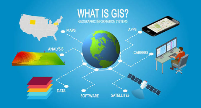
With this background, Geographic Information Systems (GIS), a spatial technology is helping the educators, their students, and their institutions to deal with their personal as well as community questions from local to global level. The very big example of it is the spatial information or maps of the spread of the ongoing pandemic, COVID 19.
The spatial or map-making technology, should be used throughout primary and secondary schools, considering the need and the challenges required for its implementation. We know that conventional form of maps, the paper maps, are effective teaching tools for geography, but when maps are combined with technology, they can become visually powerful through the knowledge of GIS. GIS not only creates map but combines maps with data thereby producing digital maps that engage students in the science of where things are. The interactive features in digital maps can help the students to learn how things have changed over time. It can also help students of any grade level to work out innovative spatial projects and research solutions to real-world spatial problems like natural disasters, agriculture, energy requirements, etc. This will also help educators to inculcate a research aptitude in their students.
Educators can use already prepared explorers or tutorials with detailed information about different places to share with students. One of the popular tools and tutorials on GIS are offered by Environmental Systems Research Institute (ESRI) for the educators for classroom use. Whatever the platform, educators who use GIS in the classroom engage their students in inquiry-driven, problem-solving activities that are aligned to state standards. The application of GIS in the classroom can also prepare students to know about the variety of career pathways in the spatial digital domain that are in demand.
Students are already familiar with the application of GIS in their mobile or play station games which are a blend of real and virtual environments, for example the game of Pokemon Go. Students are familiar with the urban environments displayed in their video games, which are created by GIS software, such as City Engine. Different GIS software is also used for film, simulations, and virtual reality. Nowadays, any student who has been in a car with GPS or has used a mobile application with interactive maps applications from Google, Bing, Apple, or Waze has experienced how the data from GPS and analysed by GIS (systems) can blend their real world with a virtual world. Student familiarity with GIS helps their understanding of how GIS applications operate in the real world.
Though, GIS is important from the academics, teaching-learning, perspective, there are other educational applications of GIS too. A GIS can support primary, secondary, higher secondary schools in decision and policy making. For example, a GIS can provide district administrators and community safety experts the information about school buildings and surrounding areas to design and manage safety programs. GIS helps determine school attendance boundaries, campus locations (new ones and those needing to close), efficient bus routes (consider the task of routing 250 buses every day to pick up and drop off 10,000 kids, for example), classroom and facilities capacities, emergency plans and evacuation routes, and much more.
The GIS can also provide school administrators with tools to visualize patterns in student needs in attendance, academic achievement, or after-school support. Thus, GIS can be an effective tool used by all stakeholders of education sector.
Finally, to conclude, whichever way GIS is approached, there are three important things that students are learning:
Content or Fundamental knowledge – for example, the ecosystem, the hydrologic cycle, human and environment interaction, etc.
Skills – for example, oral and written communication, use of digital technology, working with spatial data, etc.
Spatial or Geographic perspective – encouraging students to learn to think every situation in why (reason), when (time) and where (space) domain.
Dr. Reshma Raskar-Phule
Faculty, Sardar Patel College of Engineering, Andheri, Mumbai
M.Tech., Ph.D – Remote Sensing Technology, IIT Bombay


 for Schools)